West, Helmond
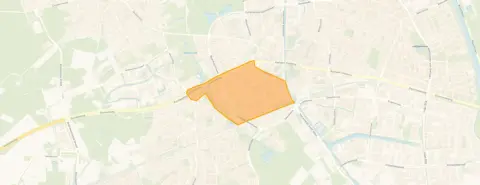 Neighbourhood
This two-room apartment on Cortenbachstraat in Helmond-West is a social housing rental, listed at €525 per month. The rent is 63% below the neighbourhood average of €1,407, which makes it a keen option for those eligible for social housing. The floor area of 51 m² is 30% smaller than the average in the area, so the space is compact. For a sense of what else is available, you can compare with other apartments in Helmond.
West is a mixed neighbourhood with a strong urban feel, given the high address density. According to CBS data, it's home to many single-person households (44%) and a fair share of families with children (32%). Residents give it an average score of 7.84, though the reviews are mixed. One resident says: "Lovely place to live but that loveliness is increasingly being taken away by growing drug nuisance." Another notes: "becoming increasingly criminal and growing Islam." A third simply says: "a lot of drug nuisance." These are the voices of three residents, so they reflect personal experiences. To get a broader picture, you can look at the West neighbourhood.
Daily errands are easy from here. The nearest supermarket, a Jumbo, is just around the corner, and an Ekoplaza is a ten-minute walk away. For schools, Kindcentrum Westwijzer is a couple of streets away, and Jan van Brabant College is about 889 metres, so a ten-minute walk for secondary education. The area also has a park within a short stroll, and the train station is 1.6 km away. For more on the wider area, see the municipality of Helmond.
At the time of writing, this home is listed only.
This summary was generated with AI and may contain errors. Always verify the details with the provider.
Details of this home
 Insure your home and belongingsGet insured
The WOZ value is set annually by the municipality with 1 January as its reference date, and therefore lags the market by about a year. It is an estimated market value, not a sale price.
About Cortenbachstraat 159, Helmond
The rent is €525 per month, which is 63% below the neighbourhood average of €1,407. However, this is a social housing rental, so the rent is set according to social housing rules. The floor area is 51 m², which is 30% smaller than the average in the area. Given the low rent and the compact size, the price is in line with what you'd expect for social housing.
The energy label is C. This is an official registration from EP-Online. It indicates the energy performance of the home, but it doesn't tell you about the condition of the building or its insulation. A C label is average, so you can expect moderate energy costs, but the actual costs depend on your usage and the specific heating system.
The nearest supermarket is a Jumbo at 391 metres, which is just around the corner. There's also an Ekoplaza at 782 metres, another Jumbo at 964 metres, and an Albert Heijn at 1,092 metres. So you have several options within a short walk or bike ride.
The nearest primary school is Kindcentrum Westwijzer at 219 metres. For secondary education, Jan van Brabant College is at 889 metres. There are also other primary schools within a reasonable distance, such as In het Hart van het Hout at 919 metres and OBS 't Hout at 1,135 metres.
Residents have given the neighbourhood an average score of 7.84, but the reviews mention drug nuisance. One resident says: "Lovely place to live but that loveliness is increasingly being taken away by growing drug nuisance." Another says: "a lot of drug nuisance." So while some appreciate the area, there are concerns about safety.
Yes, this is a social housing rental, as indicated in the listing. The rent is €525 per month, which is well below the social housing threshold. This means it's likely subject to income limits and allocation rules set by the housing corporation.
How residents experience their neighbourhood
Lovely place to live but that loveliness is increasingly being taken away by growing drug nuisance
Auto-translated to English by AIbecoming increasingly criminal and growing Islam
Auto-translated to English by AIa lot of drug nuisance
Auto-translated to English by AIFigures on residents, liveability and the housing market
| Sale price | €477,909 | €375,000 |
|---|---|---|
| Sale per m² | €3,493 | – |
| Rent price | €1,407 p/m | €1,385 p/m |
| Rent per m² | €19 p/m | – |
How residents experience their district
Lovely place to live but that loveliness is increasingly being taken away by growing drug nuisance
Auto-translated to English by AIbecoming increasingly criminal and growing Islam
Auto-translated to English by AIa lot of drug nuisance
Auto-translated to English by AIFigures on residents, liveability and the housing market
| Sale price | €456,833 | €362,500 |
|---|---|---|
| Sale per m² | €3,350 | – |
| Rent price | €1,407 p/m | €1,385 p/m |
| Rent per m² | €19 p/m | – |
How residents experience their municipality
Houses are being renovated and insulated on the outside, but residents remain the same, poor or no maintenance of front and back gardens. No waste enforcement.
Auto-translated to English by AIpleasant living environment, very nice neighbourhood to be in
Auto-translated to English by AILittle contact but good neighbours, wide street, normally quiet, sometimes some children shouting, a lot of rubbish is dumped on the street
Auto-translated to English by AIN/A
Auto-translated to English by AII have been living here for 24 years with great pleasure. I mainly love the beautiful surroundings with lots of greenery and the accessibility to shops and the centre.
Auto-translated to English by AIN/A
Auto-translated to English by AILovely place to live but that loveliness is increasingly being taken away by growing drug nuisance
Auto-translated to English by AISome residents are extremely dangerous. Threatening with death, I could write a book about it!!!!!
Auto-translated to English by AIFigures on residents, liveability and the housing market
| Sale price | €528,002 | €482,497 |
|---|---|---|
| Sale per m² | €3,911 | – |
| Rent price | €1,414 p/m | €1,448 p/m |
| Rent per m² | €17 p/m | – |
Cortenbachstraat 159, Helmond







Noise, foundation and climate around this address
View more homes nearby