Weduwestraat 5A
Verspreide huizen Wernhout, Zundert
 Neighbourhood
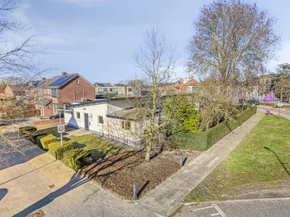
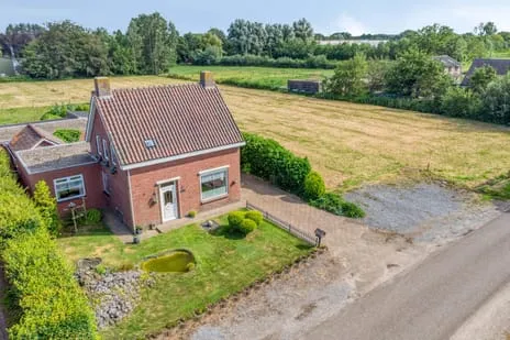
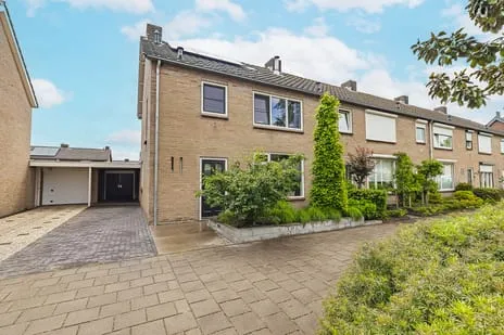
A spacious detached home on a large plot
This detached house on Weduwestraat in Zundert sits on a generous plot of 7870 m², offering plenty of outdoor space. Built in 1957, the home has 104 m² of living space and an energy label G, the least efficient label, so expect high heating costs. The asking price of €580,000 is on the high side compared to other detached houses in Zundert.
The Verspreide huizen Wernhout neighbourhood
The Verspreide huizen Wernhout neighbourhood is a rural area with a low address density of 147 addresses per km², making it very quiet. Most homes are owner-occupied (79%) and almost all are single-family houses (98%). The population is relatively older, with many residents aged 45 and over. There are no neighbourhood reviews available for this area.
Life on the street
For daily groceries, the nearest supermarket is Coop, just under a kilometre away, with Aldi and Albert Heijn within a couple of kilometres. Primary schools include Jozefschool (about a ten-minute walk) and RK Basisschool St Anna (a couple of streets away). Secondary education is further afield, with Mencia Sandrode about 2.8 km away. The area is part of the municipality of Zundert, which offers a mix of rural and village amenities.
Source and agent
At the time of writing, the home is listed through several channels, including Van Hassel Makelaars o.g. and Van Hassel Makelaars | NVM.
This summary was generated with AI and may contain errors. Always verify the details with the provider.
Features
Details of this home
Transfer
Price

Areas and volume
 Insure your home and belongingsGet insured
Layout
Construction
The WOZ value is set annually by the municipality with 1 January as its reference date, and therefore lags the market by about a year. It is an estimated market value, not a sale price.
Frequently asked questions
About Weduwestraat 5A, Zundert
Is €580,000 a fair price for this home?
The asking price of €580,000 is on the high side compared to other detached houses in Zundert. The home has a large plot of 7870 m², but the living area is 104 m² and the energy label is G, which means high energy costs. The price reflects the land value more than the house itself.
What does energy label G mean?
Energy label G is the least efficient label on the scale from A to G. It means the home's energy performance is poor, so you can expect high heating and electricity costs. The label is an official registration from EP-Online and does not specify which aspects cause the low rating.
How far is the nearest train station?
The nearest train station is 18.2 km away, so this home is not well connected by rail. You would need a car or bus for longer journeys.
What schools are nearby?
Primary schools within walking distance include Jozefschool (about 1 km) and RK Basisschool St Anna (about 1.8 km). For secondary education, Mencia Sandrode is about 2.8 km away. There are several other schools within 5 km.
Is the neighbourhood safe?
The neighbourhood recorded 29 total crimes in the latest data, which is low for a rural area. The address density is very low, so it is a quiet and sparsely populated area.
What is the plot size and can I build on it?
The plot is 7870 m², which is very large. You would need to check with the municipality of Zundert.
Statistics for Verspreide huizen Wernhout
Figures on residents, liveability and the housing market
Statistics for Wernhout
Figures on residents, liveability and the housing market
Experiences from Zundert
How residents experience their municipality
Quiet and tidy neighbourhood, very cosy in summer, well maintained and safe
Auto-translated to English by AIThe population figures are incorrect. Almost 7,000 people live in our village. Generally, the neighbourhood is quiet. Unfortunately, we look out onto a property where dealing takes place. Few ethnic minority children. But many children of status holders.
Auto-translated to English by AICosy neighbourhood with active residents who are there for each other and organise themselves together
Auto-translated to English by AIA quiet neighbourhood, few real neighbourly contacts. But there is social control. The street is getting many new young residents, which is rejuvenating it.
Auto-translated to English by AIStatistics for Zundert
Figures on residents, liveability and the housing market
| Sale price | €636,153 | €545,694 |
|---|---|---|
| Sale per m² | €3,897 | – |
| Rent price | €1,163 p/m | €1,163 p/m |
| Rent per m² | €17 p/m | – |
Location and amenities
Weduwestraat 5A, Zundert






Risks and environmental factors
Noise, foundation and climate around this address