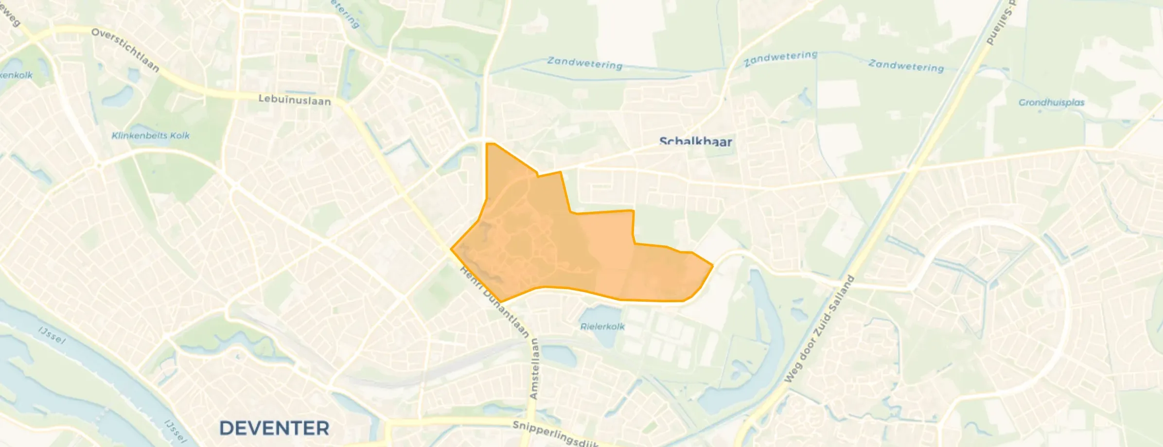
Brinkgreven
OverijsselDeventerVoorstadBrinkgreven

Brinkgreven, Deventer

Neighbourhood in Deventer

Brinkgreven has 215 residentsMost are 25 to 45 years old
There are 3 homes in BrinkgrevenCurrently there are 0 for sale and 0 for rent
Energy label B is the most common in BrinkgrevenBased on registered homes

Brinkgreven is located in the province of Overijssel, in the municipality of Deventer, in the district Voorstad The neighbourhood has a total area of 71 hectares, of which 71 hectares are land and 0 hectares are water. The neighbourhood is coded as BU01500407. The postcode area is 7415CG-7416SE.

Residents

Brinkgreven has 215 residents. Of these, 65,1% are men and 32,6% are women. Most residents are 25 to 45 years (37,2%). The other age groups are 32,6% for '45 to 65 years', 18,6% for '65 years or older' and 11,6% for '15 to 25 years'. Of the residents, 76,7% is unmarried, 2,3% is married, 18,6% is divorced and 2,3% is widowed. 135 residents originate from the Netherlands, 15 come from Europe and 65 come from countries outside Europe.

There are 60 households in Brinkgreven. 100,0% of these are single-person households, 0,0% households without children and 0,0% households with children. The average household size is 1,0 persons.

The average income per income recipient is €5.351, which is €30.449 (85%) lower than the national average of €35.800. Per resident, the average income is €3.369, which is €25.831 (88%) lower than the national average of €29.200.

In Brinkgreven, 60% of residents receive a benefit. The largest group is those receiving a occupational disability benefit. 90 people receive this benefit.

Housing

In Brinkgreven there are 3 homes with an average assessed value (WOZ) of €156.364. Of these, around 71% are occupied and 2% unoccupied. Most homes are owner-occupied. This amounts to 44% rental homes and 56% owner-occupied homes. Of the homes, 57% privately owned, 36% owned by housing associations and 7% owned by other landlords. The most common construction periods in Brinkgreven are 1970-1980 (44%) and 2000-2010 (33%).

Homes for sale

There are currently no homes for sale in Brinkgreven. The most recently listed home is Nico Bolkesteinlaan NAN by Bronsvoord Makelaars op Pararius. No homes were sold in Brinkgreven over the past year.

Rental homes

There are currently no homes for rent in Brinkgreven. No homes were let in Brinkgreven over the past year.

No recent rental data available for Brinkgreven.

Energy

In Brinkgreven there are 4 addresses with a registered energy label. The most common labels are B (50%), E (25%) and F (25%). On average, an address in Brinkgreven uses 2.364 kWh of electricity per year. This is 16% below the national average of 2.810 kWh. Natural gas consumption, at 1.400 m³ per year, is 9% above the national average of 1.280 m³.

Street names

  • Brinkgreverweg
  • Raalterweg
  • Mensinksdijkje
  • Nico Bolkesteinlaan

Amenities

GP
0,2 km
Pharmacy
0,9 km
Hospital
1,3 km
Supermarket
1,3 km
Railway station
2,3 km
Day nursery
0,8 km
Primary school
1,6 km
Secondary school
1,1 km
View homes in Brinkgreven

Easily find available homes, schools and supermarkets on our map.

View homes for sale View homes for rent
Rate Brinkgreven

Share your opinion and help improve the neighbourhood.

  • Takes less than 2 minutes
  • Help home seekers
  • Improve your neighbourhood
Write a review
Brinkgreven has no ratings yet
Ratings can be submitted via the button below
Write a review
Safety
Housing
Cleanliness
Amenities
Education
Community
Greenery
Accessibility

Statistics about the residents

Ages

Residents per age category

Household composition

Households per category
60Single-person households
0Households without children
0Households with children

Gender

Residents by gender
Men
Women

Marital status

Residents by marital status
Married
Unmarried
Divorced
Widowed

Origin

Residents per category of origin
Netherlands
Europe
Outside Europe

Work & income

Labour participation and average income
€3,369 P.A.average per resident89% below the national average
€5,351 P.A.average per income recipient86% below the national average
0%is in paid employment
0%is self-employed
0%
of the residents are employed
72%
is the national average

Education level

Residents per education level
VMBO, MBO 1
HAVO/VWO, MBO 2-4
HBO/WO

Wealth

Median wealth per household
Brinkgreven
Netherlands

Benefits

Residents per benefit type
Social assistance
Disability
Unemployment
Sponsored
View more than 250 topics about Brinkgreven in clear figures and charts on AlleCijfers.nl!
View on AlleCijfers.nl

Housing market in Voorstad

Figures for the district Voorstad due to limited data

Sales market

Market speed and dynamics, last 12 months
69 days
average time listed · vs. last year
44
sales in the past year
116 m²
average living area
€145.000
lowest sale price in the past year

Rental market

Market speed and dynamics, last 12 months
30 days
average time listed · vs. last year
10
lettings in the past year
97 m²
average living area
€1.250
lowest rent in the past year

Year built

Age of the housing stock

Energy labels

Sustainability of the housing stock

Living area

Distribution of home sizes

Statistics about the homes

Home types

Addresses per home type

Construction periods

Addresses per construction period

Labels

Addresses per energy label

Energy consumption

Average per address, compared with the Netherlands
Natural gas (m³)
Brinkgreven
1.400
Netherlands
1.280
Electricity (kWh)
Brinkgreven
2.364
Netherlands
2.810

Frequently asked questions about Brinkgreven

What kind of houses make up Brinkgreven?

The housing stock is predominantly pre-war — 60% of the homes date from before 1945. In addition, the most common type is flats (100%).

What is the average asking price in Brinkgreven?

Over the past year a home for sale in Brinkgreven was listed for an average of €398,477 (€4,136 per m²).

How much does renting cost in Brinkgreven?

A rental home in Brinkgreven cost an average of €1,445 per month (€16 per m²).

How is the population of Brinkgreven composed?

Buurt Brinkgreven has 215 residents. The largest age group is 25 to 45 years (37%).

What are the energy labels in Brinkgreven?

A considerable share of the supply in Brinkgreven is less efficient: 26% has an E, F or G label. The average natural gas consumption per household is 1,400 m³ per year.

How far are amenities from Brinkgreven?

From Brinkgreven you can on average reach a supermarket at 1.3 km, a GP at 0.2 km, a railway station at 2.3 km, a primary school at 1.6 km (as the crow flies, source: CBS).

Buurtje.nl
Buurtje.nl in the appSearch faster and respond first
Open


