Bunschoten
Utrecht›Bunschoten›Wijk 00›Bunschoten

Bunschoten, Bunschoten

Neighbourhood in Bunschoten

Bunschoten has 3,250 residentsMost are 25 to 45 years old
There are 1,263 homes in BunschotenCurrently there are 29 for sale and 0 for rent
Energy label A is the most common in BunschotenBased on registered homes

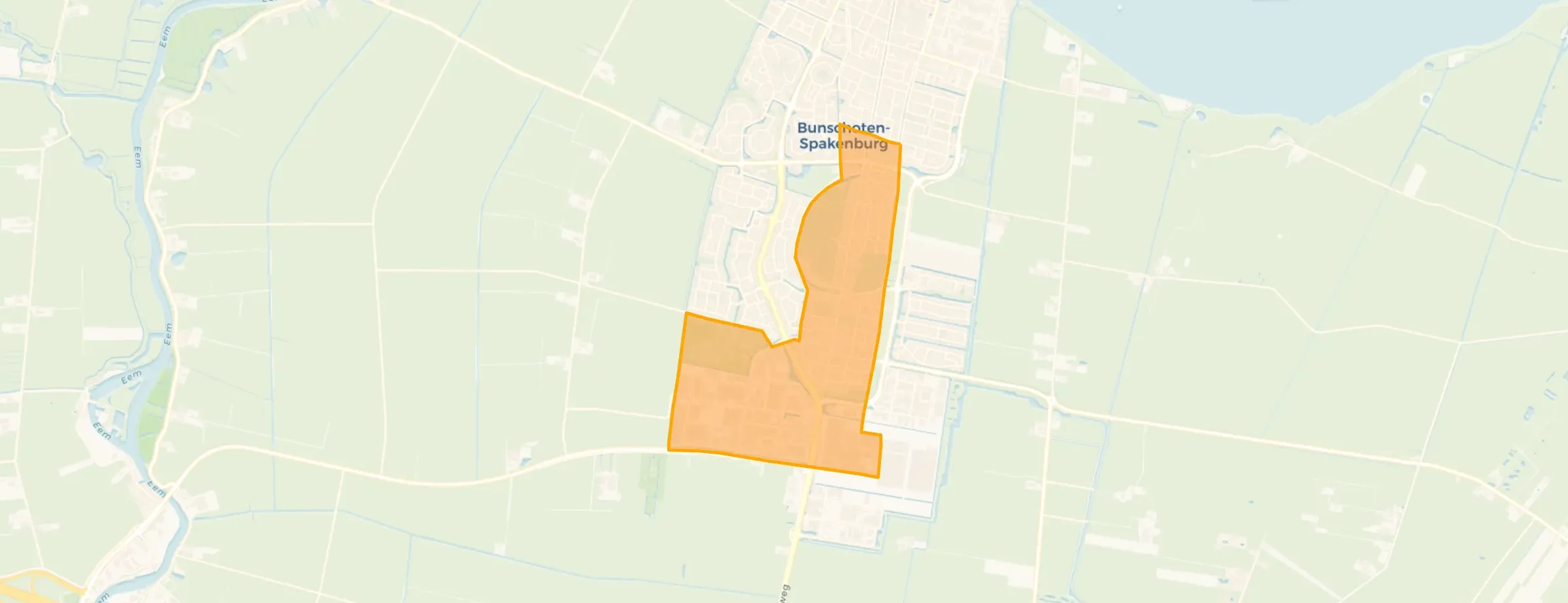
Bunschoten is located in the province of Utrecht, in the municipality of Bunschoten, in the district Wijk 00 The neighbourhood has a total area of 151 hectares, of which 150 hectares are land and 1 hectares are water. The neighbourhood is coded as BU03130001. The postcode area is 3751CW-3752XW.

Residents

Bunschoten has 3.250 residents. Of these, 51,7% are men and 48,5% are women. Most residents are 25 to 45 years (27,8%). The other age groups are 26,5% for '45 to 65 years', 18,2% for '0 to 15 years', 14,2% for '15 to 25 years' and 13,4% for '65 years or older'. Of the residents, 45,2% is unmarried, 46,6% is married, 5,5% is divorced and 2,6% is widowed. 2.710 residents originate from the Netherlands, 245 come from Europe and 295 come from countries outside Europe.

There are 1.260 households in Bunschoten. 27,0% of these are single-person households, 28,6% households without children and 44,4% households with children. The average household size is 2,6 persons. The national average is 2,1 persons.

In Bunschoten there are 2.600 income recipients. The average income per income recipient is €41.900, which is €300 (1%) lower than the national average of €42.200. Per resident, the average income is €33.500, which is €1.400 (4%) lower than the national average of €34.900. Most residents of Bunschoten are educated to an intermediate level. 49,8% have an intermediate education (HAVO, VWO or MBO 2-4), 29,3% have a lower education (VMBO or MBO 1) and 20,9% have a university or higher professional education (HBO/WO).

Of the 3.250 residents, around 81% are in paid employment, which amounts to 2.633 people. This is 9% higher than the national average of 72%. The majority of workers are in salaried employment (82%), while 18% are self-employed. In Bunschoten, 16% of residents receive a benefit. The largest group is those receiving a state pension (AOW). 360 people receive this benefit.

Housing

In Bunschoten there are 1.263 homes with an average assessed value (WOZ) of €465.000. Of these, around 96% are occupied and 4% unoccupied. Most homes are owner-occupied. This amounts to 29% rental homes and 71% owner-occupied homes. Of the homes, 71% privately owned, 13% owned by housing associations and 16% owned by other landlords. The most common construction periods in Bunschoten are 1950-1970 (33%) and 1990-2000 (12%).

Homes for sale

There are currently 26 homes for sale in Bunschoten. The most recently listed home is Paulus Potterstraat 14 by Huis en Zekerheid Spakenburg. Over the past year, 131 homes were sold in Bunschoten. On average, a home was sold within 90 days.

The average asking price for a home for sale in Bunschoten over the past year was €661.481. This is 42% higher than the average assessed value (WOZ) of €465.000. The average asking price per m² of plot is €5.467.

Rental homes

There are currently no homes for rent in Bunschoten. The most recent home is Bunschoter Kom 2, offered by Interhouse makelaars Amersfoort op Funda. Over the past year, 12 homes were let in Bunschoten. On average, a listing was let within 28 days.

No recent rental data available for Bunschoten.

Energy

In Bunschoten there are 666 addresses with a registered energy label. The most common labels are A (24%), C (21%) and B (17%). On average, an address in Bunschoten uses 3.160 kWh of electricity per year. This is 24% above the national average of 2.550 kWh. Natural gas consumption, at 950 m³ per year, is 19% above the national average of 800 m³.

Street names

  • Sint Nicolaashoofd
  • Rengersweg
  • Prinses Irenestraat
  • Grebbelinie
  • Kostverloren
  • Dieselweg
  • Paulus Potterstraat
  • Bisschopsweg
  • Eemlandia
  • Jan Pieterszoon Coenstraat
  • Rembrandt van Rijnstraat
  • Melkrijder
  • Westsingel
  • Albert Cuypstraat
  • Kolkweg
  • Prins Clausstraat
  • Engelandvaarders
  • Prins Johan Frisostraat
  • Voltaweg
  • Burgwal
  • Fahrenheitweg
  • Vondelstraat
  • Marconiweg
  • Schoolstraat
  • Lorentzweg
  • Sint Nicolaasweg
  • Stadsspui
  • Bunschoter Kom
  • Frits de Zwerver
  • De Kleine Pol
  • Bilderdijkstraat
  • Oostelijke Randweg
  • Johannes Vermeerstraat
  • Kolkplein
  • Archimedesweg
  • Nicolaas Beetsstraat
  • Ampèreweg
  • De Kronkels
  • Jan van Riebeeckstraat
  • Einsteinweg
  • De Steiger
  • Willem Barentszstraat
  • Koningin Wilhelminastraat
  • Abel Tasmanstraat
  • Röntgenweg
  • Chopinstraat
  • Koerierster
  • Bosmanshof
  • Veenestraat
  • Verlengde Oostsingel
  • Pascalweg
  • Jan Steenstraat
  • Poststraat
  • Stadsgracht
  • Nijkerkerweg
  • Floris van Dijckstraat
  • Dirk van Hulststraat
  • Amersfoortseweg
  • Celsiusweg
  • Da Costastraat
  • Botermarkt
  • Frans Halsstraat
  • Anne Frank
  • Kolkkamp
  • Bikkersweg
  • Johannes Post
  • Molenstraat
  • Edisonweg
  • Oosterstraat
  • Copernicusweg
  • Dorpsstraat
  • Cornelis Houtmanstraat

Amenities

GP
1,2 km
Pharmacy
1,2 km
Hospital
8,1 km
Supermarket
1,0 km
Railway station
8,5 km
Day nursery
0,6 km
Primary school
0,4 km
Secondary school
1,1 km
View homes in Bunschoten

Easily find available homes, schools and supermarkets on our map.

View homes for sale View homes for rent
Rate Bunschoten

Share your opinion and help improve the neighbourhood.

  • Takes less than 2 minutes
  • Help home seekers
  • Improve your neighbourhood
Write a review
–
Bunschoten has no ratings yet
Ratings can be submitted via the button below
Write a review
Safety
Housing
Cleanliness
Amenities
Education
Community
Greenery
Accessibility

Statistics about the residents

Ages

Residents per age category

Household composition

Households per category
340Single-person households
360Households without children
560Households with children

Gender

Residents by gender
Men
Women

Marital status

Residents by marital status
Married
Unmarried
Divorced
Widowed

Origin

Residents per category of origin
Netherlands
Europe
Outside Europe

Work & income

Labour participation and average income
€33,500 P.A.average per resident4% below the national average
€41,900 P.A.average per income recipient1% below the national average
82%of the employed are in paid employment
18%of the employed are self-employed
81%
of the residents are employed
72%
is the national average

Education level

Residents per education level
VMBO, MBO 1
HAVO/VWO, MBO 2-4
HBO/WO

Wealth

Median wealth per household
Bunschoten
Netherlands

Benefits

Residents per benefit type
Social assistance
Disability
Unemployment

Housing market in Bunschoten

Sale price · Q4 2026
€712.222
average▲ 10,3%
€490.000
median▼ 13,0%
9 sales · vs. Q3 2026
€/m² for sale · Q4 2026
€7.142
average▲ 41,8%
€5.000
median▲ 4,7%

Price trend for sale

Sale price per quarter · Q4 '25 – Q4 '26
Average
Median

Sales market

Market speed and dynamics, last 12 months
88 days ▲ 58,2%
average time listed · vs. last year
124
sales in the past year
133 m²
average living area
€295.000
lowest sale price in the past year

Rental market

Market speed and dynamics, last 12 months
27 days ▼ 72,3%
average time listed · vs. last year
7
lettings in the past year
323 m²
average living area
€1.205
lowest rent in the past year

Year built

Age of the housing stock

Energy labels

Sustainability of the housing stock

Living area

Distribution of home sizes

Statistics about the homes

Home types

Addresses per home type

Construction periods

Addresses per construction period

Labels

Addresses per energy label

Energy consumption

Average per address, compared with the Netherlands
Natural gas (m³)
Bunschoten
950
Netherlands
800
Electricity (kWh)
Bunschoten
3.160
Netherlands
2.550

Frequently asked questions about Bunschoten

What does the housing stock in Bunschoten look like?

The housing stock is mainly post-war — 68% was built between 1945 and 1990.

How much does a home cost in Bunschoten?

Over the past year a home for sale in Bunschoten was listed for an average of €647,984 (€5,053 per m²). Last quarter prices rose by 10%.

How is the population of Bunschoten composed?

Buurt Bunschoten has 3,250 residents. Many families: 44% of the households have children.

What are the energy labels in Bunschoten?

The housing supply in Bunschoten is remarkably efficient: 68% has an A, A+ or B label. The average natural gas consumption per household is 950 m³ per year.

How far are amenities from Bunschoten?

From Bunschoten you can on average reach a supermarket at 1.0 km, a GP at 1.2 km, a railway station at 8.5 km, a primary school at 0.4 km (as the crow flies, source: CBS).

How many homes are currently for sale in Bunschoten?

Right now you will find 29 homes for sale in Bunschoten. A home for sale here is listed for an average of 87 days — relatively long for the current market.

Buurtje.nl
Buurtje.nl in the appSearch faster and respond first
Open