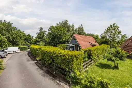





A waterside home in Oostmahorn
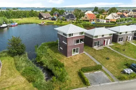
This detached house sits on the water in Oostmahorn, a small settlement within the municipality of Noardeast-Fryslân. The asking price of €155,000 is keen compared with the neighbourhood average asking price of €212,814. The home is one of the detached houses in Noardeast-Fryslân currently on the market.
The home itself
Built in 2006, this two-storey home has three rooms, two bedrooms and one bathroom. The living area is listed as 88 m² by the agent, while the BAG registration records 1,686 m². The plot is given as 108 m² by the agent, but the BAG registration states 1,564 m². The property has a front and rear garden facing northwest, a parking space, and full ownership. Heating is via a central heating boiler. The energy label is A, an efficient label.
Life in Oostmahorn
Oostmahorn is a quiet spot with around 95 residents, many of them older. Across the municipality of Noardeast-Fryslân, residents give an average score of 7.55 out of 10, based on 22 reviews. One resident describes the neighbourhood as "friendly, helpful and generally nice, organising neighbourhood barbecues and a few other neighbourhood events." Another review, however, mentions "death threats, drug trafficking, fights, illegal pirate radio." A third resident says "more consideration should be given to the people living in the city centre." The reviews reflect a range of experiences. For more on the area, see the Oostmahorn neighbourhood.
Amenities and transport
For daily needs, the PLUS supermarket is a ten-minute walk away, and there are two primary schools within a similar distance, including Christelijke Basisschool De Eker. The nearest GP and pharmacy are further out, in Zoutkamp and Kollum respectively. The bus stop De Skâns-Oostmahorn is just around the corner, served by line 7311. The nearest train station is Buitenpost, about 13 km away. The municipality of the municipality of Noardeast-Fryslân covers a wide rural area.
WOZ and address data
No WOZ value is available for this property. According to area-level risk data, the noise from road traffic is 40 dB Lden, which is not above the noise standard. The foundation risk indication is low, though the soil is clay, which is sensitive to settlement. Pluvial flooding risk is low, and current flood risk is low, but by 2050 the flood risk is indicated as medium. Heat stress is currently low, but is expected to become medium by 2050. These are area-level indications, not an inspection of this specific home.
Source
At the time of writing, the home is offered via multiple channels, including Vakantiemakelaar, Funda and Pararius.
This summary was generated with AI and may contain errors. Always verify the details with the provider.
Features
Details of this home
Transfer
Price

Areas and volume
Layout
Construction
Outdoor space
Frequently asked questions
About Skânserwei 28-110, Eanjum
How does the asking price compare with other homes in the area?
The asking price of €155,000 is 27% below the neighbourhood average asking price of €212,814. The price per square metre, based on the agent's listed living area of 88 m², is €1,761, which is 28% below the neighbourhood average of €2,457 per m². This comparison is precomputed from the available market data.
What is the layout of this home?
According to the agent, this is a two-storey detached house with three rooms, two bedrooms and one bathroom. The living area is listed as 88 m² by the agent, while the BAG registration records 1,686 m². The plot is given as 108 m² by the agent, but the BAG registration states 1,564 m². The home has a front and rear garden facing northwest, and a parking space.
What is the energy label and what does it mean?
The energy label is A, which is an efficient label. This means the home is likely to have relatively low energy costs compared with less efficient labels. The label is a standardised measure of the energy performance of the building, based on its insulation, heating system and other factors. No further details about the insulation or heating installation are stated in the listing.
What is the foundation risk for this property?
The foundation risk indication for this address is low, according to area-level data. The soil is clay, which is sensitive to settlement. This is an area-level indication, not an inspection of this specific home. The data comes from public sources such as KCAF and Atlas Leefomgeving, and does not replace a structural survey.
What are the flood risks for this area?
According to area-level climate data, the current flood risk is low, and the risk of pluvial flooding (from heavy rain) is also low. By 2050, the flood risk is indicated as medium. Heat stress is currently low but is expected to become medium by 2050. These are area-level indications, not predictions for this specific property.
What amenities are nearby?
The nearest supermarket is PLUS, about 2.2 km away, which is a ten-minute walk. There are two primary schools within 5 km, including Christelijke Basisschool De Eker at about 2 km. The nearest GP is Huisarts Plus Apotheek Zoutkamp in Zoutkamp, about 10 km away, and the nearest pharmacy is Service Apotheek It Krúswâld Kollum in Kollum, about 10.7 km away.
How is the public transport in this area?
The nearest bus stop is De Skâns-Oostmahorn, about 558 metres away, served by bus line 7311. Other stops include Ezumazijl at about 1.9 km with line 7021, and Eanjum, Nieuweweg at about 2.3 km with lines 51, 355 and 7431. The nearest train station is Buitenpost, about 13.3 km away. No travel times or destinations are stated.
What is the neighbourhood like?
Oostmahorn is a small settlement with about 95 residents. Half of the households are single-person households, and the average household size is 1.8. The age profile is older, with 26% of residents aged 65 or over. Resident reviews from across the municipality of Noardeast-Fryslân give an average score of 7.55 out of 10, based on 22 reviews, with mixed comments.