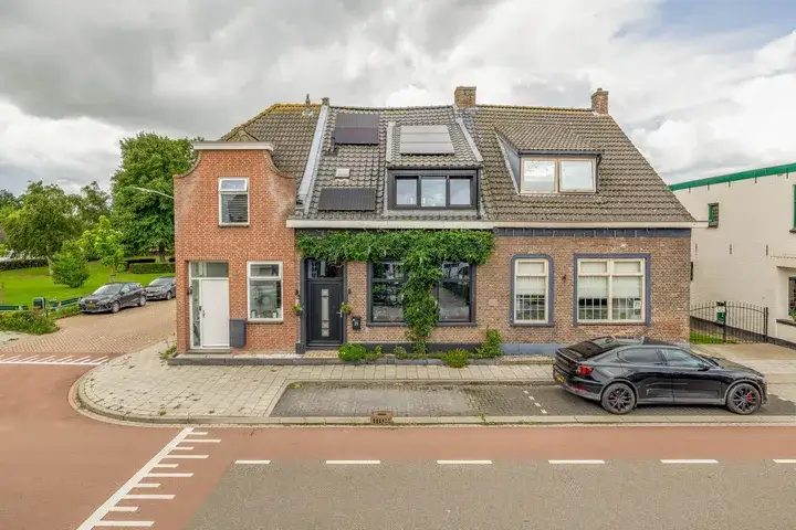





A dike house with a modern heart
This semi-detached house on Steenweg 109 sits on a quiet road in a residential area of Moerdijk, a village where life moves at a gentle pace. The home was built in 1950 and carries an energy label A, which is an efficient label. The asking price is €433,800. For context, the average asking price for semi-detached houses in Moerdijk is €480,286.
Inside the home
The agent describes a two-storey home with three rooms, two bedrooms and one bathroom. The living area is listed as 94 m² by the agent, while the BAG registration records 141 m². Similarly, the plot is 162 m² according to the agent, but the BAG registration states 100 m². The home has a front garden and a rear garden of 32 m², with the rear garden facing southeast and accessible via the back alley. There is a balcony, a basement garage, and the property is freehold. According to the agent, the insulation includes mostly double glazing, HR glazing, wall insulation and floor insulation. The heating system consists of a combination boiler, partial underfloor heating and a heat pump.
Life in Moerdijk
Moerdijk is a village of about 1,010 residents, where a third of households have children. Residents across the municipality of Moerdijk give their living environment an average score of 7.54, based on eight reviews. One resident says: "A good neighbourhood where people can live together pleasantly." Another adds: "Involved, connecting, cosy." The village has a mix of ages, with 22% of residents aged 65 or over. The housing stock is mostly owner-occupied, at 64%. For more on the area, see the Moerdijk neighbourhood.
Amenities and transport
The nearest primary school, interconfessionele basisschool De Klaverhoek, is just around the corner. A bus stop at Moerdijk, Havenkant, is on your doorstep, served by bus line 218. The nearest train station is Lage Zwaluwe, about 3.9 km away. The nearest GP is Huisartsenpraktijk Den Hoek in Zevenbergschen Hoek, about 5 km away, and the nearest pharmacy is BENU Apotheek Strijen, about 6.5 km away. For a wider look at the surroundings, see the municipality of Moerdijk.
WOZ and address data
The WOZ value is not stated in the available data, so no comparison with the asking price or historical development can be made. The address-level risk data from public sources (Atlas Leefomgeving, KCAF, Klimaateffectatlas) gives area-level indications, not an inspection of this specific home. The noise level from road traffic is 45 dB Lden, which is not above the noise standard, and from rail traffic it is also 45 dB Lden, not above the standard. The foundation risk indication is medium, with notes that the home was built in 1950 on clay soil, possibly with wooden piles or a shallow foundation, and that 93% of properties in this postcode area were built before 1970. For climate risks, pluvial flooding at heavy rain is elevated, flood risk is medium now and in 2050, and heat stress is low now but medium in 2050.
Source and agent
At the time of writing, the home is offered via multiple channels, including Van Herk Makelaars and Van der Giessen & Van Herk Makelaars.
This summary was generated with AI and may contain errors. Always verify the details with the provider.
Features
Details of this home
Transfer
Price
Energy
 Save up to € 400 on your energy billCompare now
Areas and volume
Layout
Construction
Outdoor space
Frequently asked questions
About Steenweg 109, Moerdijk
What is the asking price for this semi-detached house?
The asking price is €433,800. The average asking price for semi-detached houses in Moerdijk is €480,286, and the median is €463,800. The price per square metre, based on the agent's listed living area of 94 m², is €4,615.
How many rooms and bedrooms does this home have?
The agent describes a two-storey home with three rooms, two bedrooms and one bathroom. The living area is listed as 94 m² by the agent, while the BAG registration records 141 m². The plot is 162 m² according to the agent, but the BAG registration states 100 m². There is a balcony, a basement garage, and a rear garden of 32 m² facing southeast.
What is the energy label and what does it mean for costs?
The energy label is A, which is an efficient label. This means the home is likely to have relatively low energy costs compared to less efficient labels. The agent also mentions insulation including mostly double glazing, HR glazing, wall insulation and floor insulation, as well as a heating system with a combination boiler, partial underfloor heating and a heat pump.
What is the WOZ value of this property?
The WOZ value is not stated in the available data. As a result, no comparison with the asking price or historical development can be made.
What are the foundation risks for this home?
The foundation risk indication for this address is medium, based on area-level data from KCAF. The notes mention that the home was built in 1950 on clay soil, possibly with wooden piles or a shallow foundation, and that 93% of properties in this postcode area were built before 1970. This is an area-level indication, not an inspection of this specific home.
What is the nearest primary school and how far is it?
The nearest primary school is interconfessionele basisschool De Klaverhoek, at 454 metres, which is just around the corner. There is also a kindergarten at a similar distance. For secondary education, the nearest school is about 8 km away, so a longer trip is needed for older children.
What public transport options are available nearby?
The nearest bus stop is Moerdijk, Havenkant, at 103 metres, served by bus line 218. There are also stops at Moerdijk, Wilhelminaplein (134 metres) and Moerdijk, Steenweg (391 metres), all on the same line. The nearest train station is Lage Zwaluwe, about 3.9 km away.
What do residents say about living in Moerdijk?
Residents across the municipality of Moerdijk give their living environment an average score of 7.54, based on eight reviews. One resident says: "A good neighbourhood where people can live together pleasantly." Another adds: "Involved, connecting, cosy." These reviews describe the wider municipality, not specifically this neighbourhood.
How does the living area compare to the neighbourhood average?
The agent lists the living area as 94 m², which is 35% smaller than the neighbourhood average of 145 m². The BAG registration records a larger living area of 141 m². The difference between the two sources is not explained in the listing.