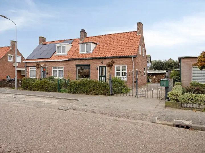
A detached house in the heart of Aalst
This detached house on Prinses Wilhelminastraat 17 sits in the centre of Aalst, on a quiet road within a residential area. The village atmosphere is immediately noticeable, with a dike, a canal and plenty of nature around, as residents of the district describe it. The last known asking price of €392,500 was on the high side compared with the neighbourhood average asking price of €346,500. For context, [detached houses in Zaltbommel]( /koopwoningen/zaltbommel/vrijstaande-woningen/) are part of the local market. This home has not been online since 24 October 2026.
The home itself
Built in 1980, this two-storey detached house has four rooms, including three bedrooms and one bathroom. The living area was 111 m² according to the agent, while the BAG registration records 98 m². The plot measured 358 m² per the agent, against 305 m² in the BAG registration. The house has a garden around it, partial double glazing and a central heating boiler. It was offered in full ownership.
Life in Aalst
Aalst is a village on a dike, with a canal and lots of nature around, as one resident puts it. Another resident mentions good communication with fellow villagers and a safe atmosphere, calling it a very pleasant neighbourhood. A third review describes a tidy neighbourhood, though street maintenance could be better. Across the district of Brakel, residents give an average score of 7.97 based on seven reviews. The village has around 1,540 inhabitants, with a mix of ages and household types. [The Aalst neighbourhood]( /buurt/aalst-zaltbommel/) offers a close-knit community feel.
Amenities and transport
Daily errands are easy from here. The Jumbo supermarket is a ten-minute walk away, and there are several other supermarkets within a short drive. Two primary schools are just around the corner: Openbare Basisschool Den Boogerd and School met de Bijbel 'De Burcht'. The GP practice Huisartsenpraktijk de Emmahof is on your doorstep, while the nearest pharmacy is a few kilometres away. Bus stops on the Kerkstraat and Zonnepad are just around the corner, served by lines 68 and 268. The nearest train station is Zaltbommel, about ten kilometres away. [The municipality of Zaltbommel]( /gemeente/zaltbommel/) covers the wider area. The address-level risk data from public sources indicates a medium foundation risk, based on clay soil that is sensitive to settling, and a KCAF attention area where 67% of properties in this postcode area were built before 1970. These are area-level indications, not an inspection of this specific home. Road traffic noise is measured at 44 dB Lden, which stays below the noise standard. Pluvial flooding risk is low, while current flood risk is medium, as is the 2050 projection. Heat stress is currently low but is expected to become medium by 2050.
Source and agent
When this home was still on the market, it was offered via multiple channels, including ViaJoop Makelaardij and ViaJoop Makelaardij on Funda.
This summary was generated with AI and may contain errors. Always verify the details with the provider.
Features
Details of this home
Transfer
Price
Energy
 Save up to € 400 on your energy billCompare now
Areas and volume
 Insure your home and belongingsGet insured
Layout
Construction
Outdoor space
Frequently asked questions
About Prinses Wilhelminastraat 17, Aalst
How did the asking price compare with the neighbourhood average?
The asking price of €392,500 was on the high side compared with the neighbourhood average asking price of €346,500. The price per square metre, based on the agent's living area of 111 m², was €3,536, which was 36% above the neighbourhood average of €2,604 per m². These figures come from the current listings in the area.
What is the layout of this detached house?
The house has four rooms in total, including three bedrooms and one bathroom, spread over two floors. The living area was listed as 111 m² by the agent, while the BAG registration records 98 m². The plot was 358 m² according to the agent, against 305 m² in the BAG registration. There is a garden around the house.
What is the WOZ value of this property?
The WOZ value is the municipal valuation used for property tax, and it is not available for this home in the data provided. Without this figure, no comparison with the asking price or historical development could be made.
What is the foundation risk for this address?
The foundation risk indication for this address is medium, according to public risk data. This is based on clay soil, which is sensitive to settling, and the fact that 67% of properties in this postcode area were built before 1970. These are area-level indications, not an inspection of this specific home.
What amenities are within walking distance?
The GP practice Huisartsenpraktijk de Emmahof is on your doorstep, and two primary schools, Openbare Basisschool Den Boogerd and School met de Bijbel 'De Burcht', are just around the corner. The nearest supermarket, a Jumbo, is a ten-minute walk away. Bus stops on the Kerkstraat and Zonnepad are just around the corner, served by lines 68 and 268.
What is the neighbourhood of Aalst like?
Residents of the district describe Aalst as a village on a dike, with a canal and lots of nature around. One resident mentions good communication with fellow villagers and a safe atmosphere, while another calls it a tidy neighbourhood. Across the district of Brakel, residents give an average score of 7.97 based on seven reviews.
How far is the nearest train station?
The nearest train station is Zaltbommel, which is about 9.7 kilometres away. This is the closest railway connection for this home. The distance is based on the data provided for the property.
What is the energy label of this house?
The energy label is D. This label indicates the energy performance of the home as registered. The house had partial double glazing and a central heating boiler, according to the agent. The energy label does not directly reflect the condition of the property.