1 / 15
Vrijstaande woning te koop: Klaverweide 305, Ballum
BuyAmelandDetached housesKlaverweide 305

Klaverweide 305

Verspreide huizen Ballum, Ameland

€ 795,000
Neighbourhood Verspreide huizen Ballum, BallumNeighbourhood
Detached home
No immediate neighbours
Energy label C
Insulation can make a big difference at this label
AI summary

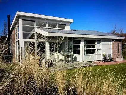
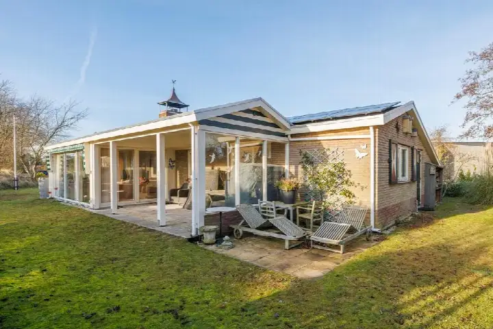
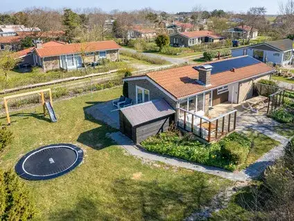
A bungalow on a spacious plot

This detached bungalow from 1966 sits in the Verspreide huizen Ballum area of Ballum, a quiet corner of Ameland. The asking price of €795,000 is on the high side compared to other [detached houses in Ameland], especially given the living area. The home is offered via multiple channels, including.

Inside the home

According to the agent, the bungalow has three rooms, two bedrooms, and two bathrooms, all on one floor. The living area is listed as 68 m² by the agent, while the BAG registration records 76 m². The plot measures 828 m². The home is fully insulated and has underfloor heating throughout. The energy label is C.

The Verspreide huizen Ballum neighbourhood

This is a small neighbourhood with about 70 residents, where a resident gives the area a 7.75 out of 10. A resident says: "When necessary, we help each other and we also greet everyone we meet." The neighbourhood is part of [the Verspreide huizen Ballum neighbourhood], which is a rural area with a low address density.

Amenities and transport

A SPAR supermarket is just around the corner, and a PLUS is a bit further away. The nearest primary school, Openbare Basisschool 't Ienster, is a ten-minute walk. The GP practice Huisarts & Apotheek Louwes is a couple of streets away. Bus stops at Snikkepad and Heideveld, served by lines 1 and 3, are within walking distance. The train station is quite far,. This is all within [the municipality of Ameland].

WOZ and address data

No WOZ value is available for this home. The address has a low foundation risk indication, based on area-level data. The noise level from road traffic is 42 dB Lden, which is below the noise standard. Pluvial flooding risk is low, and flood risk is low now but medium by 2050. These are area-level indications, not an inspection of this specific home.

Source

At the time of writing, the home is offered via multiple channels, including.

This summary was generated with AI and may contain errors. Always verify the details with the provider.

Features

Details of this home

Transfer

StatusAvailable
Listed since15 April 2026

Price

Asking price€ 795,000
Price per m²€ 10,461

Energy

Energy labelC
InsulationVolledig geïsoleerd
HeatingVloerverwarming geheel
Save up to € 400 on your energy billCompare now

Areas and volume

Living area68 m²
Object areaLand Registry (Kadaster)76 m²
Plot area828 m²
Volume284 m³
Insure your home and belongingsGet insured

Layout

Rooms3
Bedrooms2
Bathrooms2
Floors1

Construction

Property typeBungalow
Year built1966

Location

DistrictWijk 00
MunicipalityAmeland

Frequently asked questions

About Klaverweide 305, Ballum

What is the asking price for this bungalow?

The asking price is €795,000. The price per square metre, based on the agent's listed living area of 68 m², is €11,691. This is a detached bungalow from 1966 with an energy label C. The price is on the high side compared to other detached houses in Ameland, but the plot is a spacious 828 m².

How many bedrooms and bathrooms does this home have?

According to the agent, the bungalow has three rooms in total, including two bedrooms and two bathrooms. The home is all on one floor, which makes it a single-level living arrangement. The living area is listed as 68 m² by the agent, while the BAG registration records 76 m².

What is the energy label and what does it mean?

The energy label is C. This label indicates the home's energy performance, and with label C you can expect moderate energy costs. The agent states that the home is fully insulated and has underfloor heating throughout, which may help with energy efficiency, but the label itself is a separate fact.

Is there a WOZ value available for this property?

No WOZ value is stated for this property. Therefore, we cannot provide a comparison between the asking price and the WOZ value, nor any historical development of the WOZ value.

What are the foundation risks for this address?

The foundation risk indication for this address is low, based on area-level data. The home was built in 1966, and the soil type is sand. This is an area-level indication, not an inspection of this specific home. No advice is given, but you can consider this information when evaluating the property.

What is the noise level like at this address?

The noise level from road traffic is 42 dB Lden, which is below the noise standard. This is based on area-level data from 2022. This means the noise exposure is not above the legal limit, but it is still a factual indication of the acoustic environment.

What is the flood risk for this property?

The current flood risk is low, but the flood risk for 2050 is medium. Pluvial flooding risk is low. These are area-level indications from climate impact data, not a guarantee for this specific home. The risk levels are as given: low and medium.

Which supermarkets are nearby?

The nearest supermarket is a SPAR, about 591 metres away, which is just around the corner. A PLUS is about 3.9 km away, and another SPAR is about 5.1 km away. These are the closest options for groceries.

Which schools are in the area?

The nearest primary school is Openbare Basisschool 't Ienster, about 792 metres away, which is a ten-minute walk. Other primary schools within 5 km include Openbare Basisschool De Schakel and Christelijke Basisschool Koningin Wilhelmina. There is no secondary school within 5 km; the nearest is about 5.5 km away.

What public transport options are available?

The nearest bus stop is Ballum, Snikkepad, about 217 metres away, served by bus lines 1 and 3. Other stops are Ballum, Heideveld and Ballum, Vliegveld, also on lines 1 and 3. The train station is about 41 km away, so train travel requires a longer journey.

What is the neighbourhood like?

The neighbourhood is Verspreide huizen Ballum, a small area with about 70 residents. One resident gave the neighbourhood a 7.75 out of 10 and said: "When necessary, we help each other and we also greet everyone we meet." The neighbourhood has a low address density, making it a rural setting.

7.8
Residents rate Verspreide huizen Ballum as good
Based on 1 review
Safety
Housing
Cleanliness
Amenities
Education
Community
Greenery
Accessibility

Experiences from Verspreide huizen Ballum

How residents experience their neighbourhood

Join the conversation
7.8
Elise
Family · Boerderij
08-02-2025
A lot of togetherness and safety; if something is wrong, we help each other

When necessary, we help each other and we also greet everyone we meet

Auto-translated to English by AI

Statistics for Verspreide huizen Ballum

Figures on residents, liveability and the housing market

All figures
Residents
Ages
100-15
1015-25
1525-45
1545-65
1565+
Gender
Men54%
Women46%
Households
Living alone33%
Without children33%
With children33%
Education level
VMBO, MBO 120%
HAVO/VWO, MBO 2-460%
HBO/WO20%
Origin
Netherlands86%
Europe7%
Outside Europe7%
Housing market
Available soon

Location and amenities

Klaverweide 305, Ballum

SPAR
Strandweg 2
591m
PLUS
Olfert Pieter Lapstraat 4
3861m
SPAR
Torenstraat 7
5092m
Jumbo
Hoge Eggenweg 6
5398m
SPAR
Klein Vaarwaterweg 14
7332m
SPAR
Hoofdstraat 26
14977m
Coop
Lage Herenweg 42
15606m
Coop
Fonteinstrjitte 5
16354m
SPAR
Mounebuorren 8
16761m
Aldi
Beuckelaerstraat 35
19037m

Risks and environmental factors

Noise, foundation and climate around this address

Noise levels

Within limit
Road traffic reference year 202242 dB
Annual average noise level (Lden) per source; the tick marks the statutory preferred limit value. Rough indication on a 10-metre grid, not a façade assessment. Source: RIVM (Atlas Leefomgeving).

Foundation risk

Low
Year built (BAG)1966
Soil typeSand
KCAF attention areaNiet kwetsbaar gebied – 40-60 %
Homes built before 1970 in this postcode area50.0%
Homes at risk of pile rot in the neighbourhood0.0%
Homes at risk of pile rot by 20500.0%
Homes at risk of subsidence by 20501.0%
Avg. highest groundwater level26 cm below ground level
Avg. lowest groundwater level110 cm below ground level
Indication based on public sources, not a structural survey. Do the free foundation check at funderingskaartnederland.nl. Source: KCAF and BAG, a.o.

Rainwater flooding

Low
Water depth in a heavy downpour (70 mm)10 to 15 cm
Water depth in an extreme downpour (140 mm)10 to 15 cm
Position relative to surroundings7 cm higher
Water in the street during short, heavy downpours; actual nuisance depends on local drainage. Source: Klimaateffectatlas.

Flooding

Medium
Chance, current climateVery small
Chance by 2050Small
Water depth in a floodStays dry
Worst-case water depth95 cm
Probability and water depth in a flood; 2050 assumes the high scenario. Check your flood risk at overstroomik.nl. Source: Klimaateffectatlas.

Similar homes

View more homes nearby

View listing
Buurtje.nl
View this home in the appKlaverweide 305, Ballum
View