







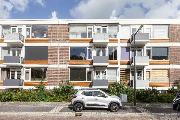
van der Werffstraat 152
Wetering, Vlaardingen
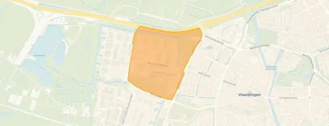 Area
AreaA 1958 apartment in Wetering
This apartment on van der Werffstraat 152 sits in the Wetering neighbourhood of Vlaardingen, a part of the Westwijk district. Built in 1958, the home carries an energy label B. The asking price of €275,000 is keen compared with the neighbourhood average asking price of €309,618, a difference of 11 percent. For context, the average asking price per square metre in the neighbourhood is €3,733, while this home comes in at €3,929 per square metre based on the BAG registration. If you are looking at [apartments in Vlaardingen], this one sits at the lower end of the price range.
The home itself
The listing does not provide details on the layout, number of rooms, or outdoor space. What is known is the year of construction, 1958, and the energy label B. The living area according to the BAG registration is 70 square metres. The asking price per square metre, based on that BAG figure, is €3,929. Without further specifications from the agent, the interior arrangement remains unknown.
Life in Wetering
Residents of the district give it an average score of 8.0, based on three reviews. One resident describes it as a "beautiful neighbourhood with many recreational opportunities" and a "green neighbourhood in the busy Rijnmond area." Another notes the area is "nice and child-friendly" with "all basic amenities available," though litter and incorrectly parked bicycles are an eyesore. A third resident mentions the difficulty of parking after half past six in the evening, sometimes having to walk nearly ten minutes from a nearby garage. The neighbourhood has around 3,600 inhabitants, with 44 percent living alone. For a closer look at [the Wetering neighbourhood], these reviews give a sense of daily life here.
Amenities and transport
Daily errands are well covered. The MCD supermarket is just around the corner, with Dirk and Aldi a couple of streets away. Primary schools De Walvis and De Schakel are on your doorstep, and secondary school Het College Vos is a five-minute walk. The GP practice De Kleine Heemtuin and Apotheek Westwijk Vlaardingen are both a ten-minute walk. For public transport, bus stop Philips de Goedestraat is just around the corner with lines 2, 56 and 156. The nearest train station, Schiedam Centrum, is about 6.1 kilometres away. The municipality of [the municipality of Vlaardingen] offers these amenities within easy reach.
WOZ and address data
No WOZ value is available for this property. The address-level risk data from public sources indicates the noise level from road traffic is 53 dB Lden, above the noise standard, while aircraft noise is 43 dB Lden, below the standard, both based on 2022 data. The foundation risk indication is low, though the home was built in 1958 on peat soil, which may mean wooden piles or a shallow foundation. These are area-level indications, not an inspection of this specific home. For climate risks, pluvial flooding at heavy rain is medium, while flood risk is low both now and in 2050. Heat stress is low currently but medium by 2050.
Source
At the time of writing the home is offered only via Makelaardij Thuis.
This summary was generated with AI and may contain errors. Always verify the details with the provider.
Features
Details of this home
Transfer
Price
Energy
 Save up to € 400 on your energy billCompare now
Areas and volume
 Insure your home and belongingsGet insured
Layout
Construction
Outdoor space
The WOZ value is set annually by the municipality with 1 January as its reference date, and therefore lags the market by about a year. It is an estimated market value, not a sale price.
Frequently asked questions
About van der Werffstraat 152, Vlaardingen
What is the asking price for this apartment?
The asking price is €275,000. This is 11 percent below the neighbourhood average asking price of €309,618, which the price verdict describes as keen. The average asking price per square metre in the neighbourhood is €3,733, while this home is listed at €3,929 per square metre based on the BAG living area of 70 square metres.
What is known about the layout of this home?
The listing does not state the number of rooms, bedrooms, or bathrooms. The living area according to the BAG registration is 70 square metres. The year of construction is 1958 and the energy label is B. No further details about the interior or outdoor space are provided in the listing.
What is the energy label and what does it mean?
The energy label is B. This label indicates the home's energy performance as registered. With label B, energy costs are relatively moderate compared with less efficient labels. The home was built in 1958, and the label reflects the registered energy characteristics of the property.
What do residents say about the district?
Residents of the district give it an average score of 8.0, based on three reviews. One resident calls it a beautiful neighbourhood with many recreational opportunities. Another says everything is easily accessible, lively and child-friendly, though litter and incorrectly parked bicycles are an eyesore. A third mentions parking is difficult after half past six in the evening.
What are the noise levels around this address?
The address-level risk data shows road traffic noise at 53 dB Lden, which is above the noise standard, based on 2022 data. Aircraft noise is 43 dB Lden, below the standard. These are area-level indications from public sources, not measurements taken at this specific home.
What is the foundation risk for this property?
The foundation risk indication is low. The home was built in 1958 on peat soil, which may mean wooden piles or a shallow foundation. This is an area-level indication based on public data, not an inspection of this specific property.
What supermarkets are nearby?
The nearest supermarket is MCD at about 522 metres, followed by Dirk at 679 metres and Aldi at 807 metres. Albert Heijn is at 833 metres. Within five kilometres there are 26 supermarkets in total, so grocery shopping is well covered in the area.
Which schools are close to this home?
Primary schools De Walvis at 89 metres and De Schakel at 158 metres are very close. Johannes Calvijnschool is at 467 metres. For secondary education, Het College Vos is at 549 metres. IKC de Wereldwijzer, another primary school, is at 734 metres.
What public transport options are available?
The nearest bus stop is Philips de Goedestraat at 246 metres, served by lines 2, 56 and 156. A second stop with the same name at 262 metres is served by line 826. Blois van Treslongstraat at 378 metres also has lines 2, 56 and 156. The nearest train station is Schiedam Centrum at about 6.1 kilometres.
What is the flood risk for this area?
The flood risk is low both currently and for 2050. Pluvial flooding at heavy rain is medium. Heat stress is low currently but medium by 2050. These are area-level indications from the Klimaateffectatlas, not specific to this property.










