De Houtmanstraat 9
Presikhaaf III, Arnhem
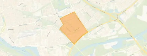 Neighbourhood
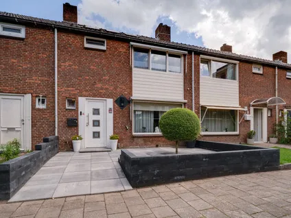
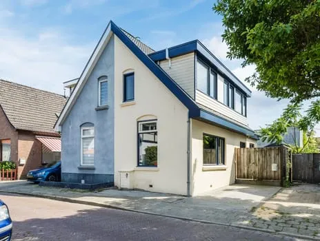
A terraced house in Presikhaaf III
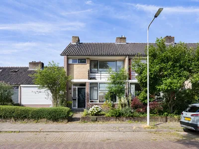
This 1963 terraced house on De Houtmanstraat 9 sits in Presikhaaf III, a neighbourhood in Arnhem where the average asking price for homes currently on the market is €240,000. At €395,000, this home's asking price is 65% above that neighbourhood average, which puts it on the high side. The living area of 86 m² is 37% larger than the neighbourhood average of 63 m², according to the BAG registration. For context, terraced houses in Arnhem are listed across a range of prices.
The home itself
This listing does not state the number of rooms, bedrooms, or bathrooms, nor does it mention any garden, balcony, or garage. The home was built in 1963 and has an energy label E, which is the least efficient label, so expect higher energy costs. The plot measures 192 m² according to the BAG registration, and the living area is 86 m². No further details about the interior or installations are provided in the listing.
Life in Presikhaaf III
Residents of the district Presikhaaf-West, which includes this neighbourhood, give their living environment an average score of 7.14, based on seven reviews. One resident says: "Nice neighbourhood with a shopping centre nearby. I regularly see people walking around cleaning up litter. Commendable!!" Another resident has mixed feelings: "When I moved here it was a reasonably good neighbourhood! but my sense of safety was gone within a few months!" The neighbourhood has about 4,400 inhabitants, and half of the households are single-person households. The crime figure for the area is 233 incidents in total, which you can interpret as you see fit. The Presikhaaf III neighbourhood is part of a larger district with its own character.
Amenities and transport
For daily groceries, Albert Heijn and Aldi are on your doorstep, both about 150 metres away, and PLUS is just around the corner. Kindcentrum De Werf, a primary school, is a couple of streets away, and De Parkschool is also nearby. The nearest GP is Huisartsenpraktijk Presikhaaf, Praktijk F.A. Ali, about 531 metres away, and the Service Apotheek Presikhaaf is. For public transport, the bus stop Arnhem, Keulse Slag is on your doorstep, served by lines 5, 26, 27, 43, 306, and 801. The train station Arnhem Presikhaaf is a ten-minute walk. The municipality of Arnhem offers these amenities within easy reach.
WOZ and address data
This listing does not include the WOZ value, so no comparison with the asking price or historical development is available. According to area-level risk data, the noise from road traffic is 53 dB Lden, which is above the standard, while railway noise is 35 dB Lden, below the standard. The foundation risk indication is medium, based on the home being built in 1963 on clay soil, which may involve wooden piles or a shallow foundation; this is an area-level indication, not an inspection of this specific home. For climate risks, pluvial flooding and flood risk are both indicated as medium for the current situation and for 2050, while heat stress is low now but medium by 2050. These are area-level indications from public data sources.
Source and agent
At the time of writing, the home is offered only via Puntman Makelaardij B.V.
This summary was generated with AI and may contain errors. Always verify the details with the provider.
Features
Details of this home
Transfer
Price
Energy
 Save up to € 400 on your energy billCompare now
Areas and volume
 Insure your home and belongingsGet insured
Layout
Construction
Outdoor space
The WOZ value is set annually by the municipality with 1 January as its reference date, and therefore lags the market by about a year. It is an estimated market value, not a sale price.
Frequently asked questions
About De Houtmanstraat 9, Arnhem
How does the asking price compare to other homes in the neighbourhood?
The asking price of €395,000 is 65% above the neighbourhood average asking price of €240,000 for homes currently for sale. The average price per m² in the neighbourhood is €3,865, while this home's price per m² is €4,593, based on the BAG living area of 86 m². This puts the home on the high side compared to the local market.
What is the living area and plot size of this home?
According to the BAG registration, the living area is 86 m² and the plot size is 192 m². The listing does not state the number of rooms, bedrooms, or bathrooms. The living area is 37% larger than the neighbourhood average of 63 m², which may appeal to those needing more space.
What is the energy label and what does it mean for costs?
The energy label is E, which is the least efficient label. This means you can expect higher energy costs compared to more efficient homes. The listing does not provide details on insulation or heating installations, so the exact costs are not stated.
What is the WOZ value of this home?
The WOZ value is the municipal valuation, which is used for taxes, and it is not provided here. Without it, a comparison with the asking price or historical development is not possible.
What are the noise levels around this address?
Area-level data indicates that road traffic noise is 53 dB Lden, which is above the standard, while railway noise is 35 dB Lden, below the standard. These are indications for the area, not measurements at the property itself. The noise levels may affect your comfort, but the actual experience can vary.
What is the foundation risk for this home?
The foundation risk indication is medium, based on the home being built in 1963 on clay soil, which may involve wooden piles or a shallow foundation. This is an area-level indication from public data, not an inspection of this specific home. The risk level suggests that foundation issues could be possible, but it is not a certainty.
What are the flood and heat stress risks for this area?
Area-level climate data indicates that pluvial flooding and flood risk are both medium for the current situation and for 2050. Heat stress is low now but medium by 2050. These are area-level indications, not predictions for this specific property. They give an idea of potential climate-related challenges.
Which supermarkets are nearby and how far are they?
Albert Heijn and Aldi are both about 150 metres away, on your doorstep. PLUS is about 343 metres away, a couple of streets away. Dekamarkt is at 833 metres, a ten-minute walk. These options cover daily grocery shopping within a short distance.
What schools are in the area?
Kindcentrum De Werf, a primary school, is about 397 metres away. De Parkschool, another primary school, is at 432 metres. Ibn-i Sina is at 458 metres. For secondary education, Mariëndael is at 421 metres, and Kentalis College Arnhem is at 564 metres. These are within walking distance.
What public transport options are available?
The bus stop Arnhem, Keulse Slag is about 76 metres away, served by lines 5, 26, 27, 43, 306, and 801. Another stop, Arnhem, IJssellaan/HAN, is at 286 metres with line 302. The train station Arnhem Presikhaaf is about 926 metres away, a ten-minute walk. These provide good connectivity.
What is the neighbourhood like according to residents?
Residents of the district Presikhaaf-West give an average score of 7.14, based on seven reviews. One resident appreciates the neighbourhood and the shopping centre, while another mentions safety concerns. The neighbourhood has about 4,400 inhabitants, with half being single-person households. The crime figure is 233 incidents in total.
Why are there no property details in this listing?
The listing does not state the number of rooms, bedrooms, bathrooms, or any details about a garden, balcony, or garage. It also does not provide information on insulation or heating installations. As a result, the layout and features of the home are not known from this listing.
Experiences from Presikhaaf III
How residents experience their neighbourhood
Often very cosy, very nice and sometimes crazy
Auto-translated to English by AIGREEN NEIGHBOURHOOD BUT NO SWIMMING POOL OR TOKO
Auto-translated to English by AIStatistics for Presikhaaf III
Figures on residents, liveability and the housing market
| Sale price | €240,000 | €235,000 |
|---|---|---|
| Sale per m² | €3,865 | – |
Experiences from Presikhaaf-West
How residents experience their district
I've been living here for over 2 years with pleasure! Nice neighbourhood with a shopping centre nearby. I regularly see people walking around cleaning up litter. Commendable!!
Auto-translated to English by AIWhen I moved here it was a reasonably good neighbourhood! but my sense of safety was gone within a few months! Someone was murdered near my flat and a while ago a firework bomb exploded at a house in the street behind my flat! "Maybe more/often police on the street"?
Auto-translated to English by AIIt's just normal, people are a bit odd though
Auto-translated to English by AIA very unsafe feeling!!! (can't get used to living in a flat and a WMO home it is not) and I would most like to leave as soon as possible!!
Auto-translated to English by AIOften very cosy, very nice and sometimes crazy
Auto-translated to English by AIThe apartment complex where I live is pleasant. And people are approachable and friendly. In the area it can sometimes be a bit restless. And there is commotion/arguments.
Auto-translated to English by AIGREEN NEIGHBOURHOOD BUT NO SWIMMING POOL OR TOKO
Auto-translated to English by AIStatistics for Presikhaaf-West
Figures on residents, liveability and the housing market
| Sale price | €333,889 | €324,444 |
|---|---|---|
| Sale per m² | €3,828 | – |
| Rent price | €1,375 p/m | €1,375 p/m |
| Rent per m² | €6 p/m | – |
Experiences from Arnhem
How residents experience their municipality
Traffic dangerous, people drive too fast and the street is narrow, two speed bumps would not be a luxury and speed control would not be out of place, but I have lived here for 46 years with great pleasure, the neighbourhood is cosy.
Auto-translated to English by AIwhat a shit neighbourhood
Auto-translated to English by AILook, you have everything in the neighbourhood: schools, city centre, supermarkets, etc. It's a bit less cosy than some other neighbourhoods in Arnhem, but certainly not bad.
Auto-translated to English by AIVery nice to live
Auto-translated to English by AII've lived here since I was a child. It's a very cosy and safe neighbourhood. It's also great for children. A park nearby and many peers.
Auto-translated to English by AII've been living here for over 2 years with pleasure! Nice neighbourhood with a shopping centre nearby. I regularly see people walking around cleaning up litter. Commendable!!
Auto-translated to English by AII live in a green environment where I get a lot of peace, it is a child-friendly neighbourhood and you have all amenities nearby
Auto-translated to English by AIWhen I moved here it was a reasonably good neighbourhood! but my sense of safety was gone within a few months! Someone was murdered near my flat and a while ago a firework bomb exploded at a house in the street behind my flat! "Maybe more/often police on the street"?
Auto-translated to English by AIStatistics for Arnhem
Figures on residents, liveability and the housing market
| Sale price | €512,125 | €432,101 |
|---|---|---|
| Sale per m² | €4,313 | – |
| Rent price | €1,653 p/m | €1,634 p/m |
| Rent per m² | €18 p/m | – |
Location and amenities
De Houtmanstraat 9, Arnhem






Risks and environmental factors
Noise, foundation and climate around this address
Noise levels
Foundation risk
Rainwater flooding
Flooding
Heat stress

Similar homes
View more homes nearby

-70f60e5a.webp)


-95af9385.webp)