Veer 99
Buitengebied Zaamslag, Terneuzen
 Area
AreaA 1911 terraced house in the countryside
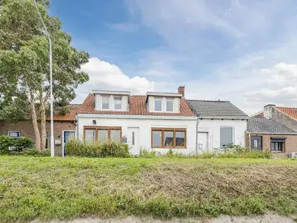
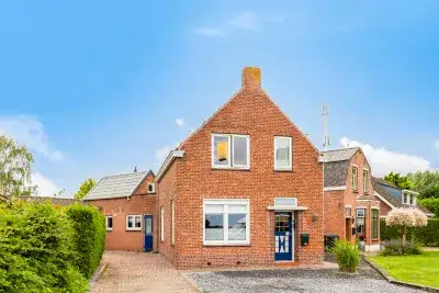
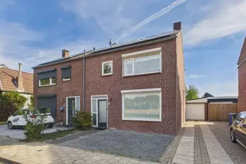
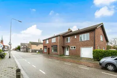
This terraced house on Veer 99 sits in the Buitengebied Zaamslag area, the rural outskirts of Zaamslag in the municipality of Terneuzen. Built in 1911, the home has a classic character that fits its agricultural surroundings. With an asking price of €350,000, the price is keen compared with the neighbourhood average asking price of €571,682. The home is one of the [terraced houses in Terneuzen] currently on the market.
The home itself
The listing does not provide details on the layout, number of rooms, or outdoor space. What is known is that the home dates from 1911 and carries an energy label C. The living area is 240 m² according to the BAG registration, with a plot of 352 m². At €1,458 per m² based on the BAG area, the price per square metre sits well below the neighbourhood average of €2,699.
Buitengebied Zaamslag
Residents across the municipality of Terneuzen give their living environment an average score of 8.03, based on 21 reviews. One resident describes it as a "perfect living environment", while another notes: "Neighbours are there for each other. Safe living and lots of green. Unfortunately, no more supermarket in the village. A great loss. But there are two bakeries and a butcher's." A third resident mentions the area is mainly 55+ and could use more greenery and accessible paths. The neighbourhood itself has around 850 inhabitants, with 26% aged 65 or over. This is the [Buitengebied Zaamslag] area.
Amenities and transport
The nearest supermarket, a SPAR, is a couple of streets away, with a second SPAR. Basisschool De Torenberg is also a couple of streets away, and Basisschool de Schakel. Huisartsenpraktijk Zaamslag is nearby, while the nearest pharmacy, Apotheek Axel, is about 5.8 km away. Bus stop Zaamslag, Veer is just around the corner, served by line 610. The nearest train station, Krabbendijke, is 18 km away. The wider area falls under [the municipality of Terneuzen].
WOZ and address data
No WOZ value is available for this property. According to public risk data at address level, the noise load from road traffic is 50 dB Lden, above the Dutch noise standard, based on 2022 data. The foundation risk indication is medium, with the home built in 1911 on clay soil, possibly on wooden piles or a shallow foundation. Pluvial flooding at heavy rain is elevated, while flood risk is low both now and in 2050. These are area-level indications, not an inspection of this specific home.
Source
At the time of writing the home is offered only via Kuub Makelaars Bevelanden NVM.
This summary was generated with AI and may contain errors. Always verify the details with the provider.
Features
Details of this home
Transfer
Price
Energy
 Save up to € 400 on your energy billCompare now
Areas and volume
 Insure your home and belongingsGet insured
Layout
Construction
Outdoor space
Frequently asked questions
About Veer 99, Zaamslag
What does the asking price of €350,000 mean for this home?
The asking price is €350,000, which is 39% below the neighbourhood average asking price of €571,682. The price per m² is €1,458 based on the BAG area, compared with a neighbourhood average of €2,699 per m². The price verdict is keen, meaning it is set below the average for similar homes in this area.
What is known about the layout of this home?
The listing does not state the number of rooms, bedrooms, or bathrooms, nor does it mention a garden, balcony, or garage. The living area is 240 m² according to the BAG registration, on a plot of 352 m². The home was built in 1911 and has an energy label C.
Why are there no property details in this listing?
The listing does not state the layout, number of rooms, or outdoor space. As a result, the description is limited to what is known: the property type, year of construction, energy label, and floor areas from the BAG registration.
What is the foundation risk for this home?
The foundation risk indication for this address is medium. The home was built in 1911 on clay soil, which may mean wooden piles or a shallow foundation. The KCAF attention area notes that 72% of properties in this postcode area were built before 1970. This is an area-level indication, not an inspection of this specific home.
What is the noise situation at this address?
The noise load from road traffic at this address is 50 dB Lden, which is above the Dutch noise standard, based on 2022 data. This is an area-level indication from public risk data, not a measurement taken at the property itself. The level is stated as it appears in the Atlas Leefomgeving.
What are the flood risks for this property?
Pluvial flooding at heavy rain is elevated for this address, while flood risk is low both now and in 2050. These figures come from the Klimaateffectatlas and are area-level indications, not an assessment of this specific home. The data does not state any consequences for the property itself.
Which supermarkets are closest to this home?
The nearest supermarket is a SPAR at about 1.9 km, with a second SPAR at 3.1 km. Further away are an Aldi at 5.7 km and an Albert Heijn at 5.8 km. Within a 5 km radius there are two supermarkets in total.
What public transport options are available nearby?
The nearest bus stop is Zaamslag, Veer at 283 metres, served by line 610. A second stop, Vogelwaarde, Stoppeldijk-Veer, is at 1 km on the same line. Zaamslag, Busstation at 1.9 km is served by lines 610 and 645. The nearest train station is Krabbendijke at 18 km.
How do residents rate living in this area?
Residents across the municipality of Terneuzen give their living environment an average score of 8.03, based on 21 reviews. One resident calls it a "perfect living environment", while another appreciates that "neighbours are there for each other" and mentions the green surroundings. These reviews describe the municipality, not specifically the Buitengebied Zaamslag neighbourhood.
What schools are near this home?
Basisschool De Torenberg is the nearest primary school at about 1.9 km, followed by Basisschool de Schakel at 2.8 km. Christelijke Basisschool de Parel and De Irisschool are both around 5.6 km away. The nearest secondary school, Lodewijk College locatie Zeldenrustlaan, is at 5.7 km.