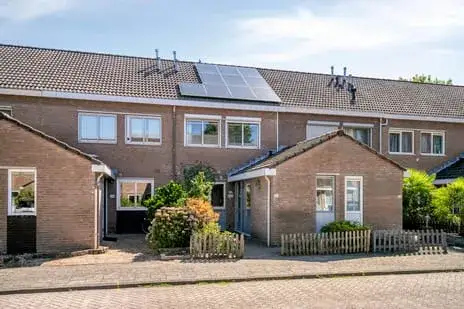
Asterstraat 2
Braken-Oost, Heusden
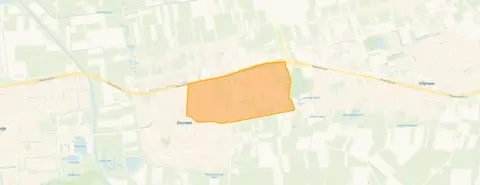 Area
AreaA classic end-of-terrace home in Drunen
Asterstraat 2 is an end-of-terrace house from 1965, sitting in the Braken-Oost neighbourhood of Drunen. The home has an energy label A, which is an efficient label, so energy costs should be relatively modest. With a living area of 118 m² and a plot of 155 m², the asking price of €425,000 works out at €3,602 per m² based on the BAG registration. That puts the price on the high side compared with other [end-of-terrace houses in Heusden].
The home itself
The listing does not provide details on the layout, number of rooms, or any outdoor space. What is known is the year of construction, 1965, and the energy label A. The home is offered for sale through a single agent, and the asking price reflects the living area and plot size as registered in the BAG.
Life in Braken-Oost
Braken-Oost is a residential area with around 3,235 residents, and a mix of ages, with a quarter of the population between 45 and 65. Residents across the municipality of Heusden give their living environment an average score of 7.33, based on eight reviews. One resident describes a "great neighbourhood in a lovely village", where neighbours help each other and amenities are close by, with nature and the countryside just a short walk away. Another resident, however, mentions "loitering youths" and concerns about safety, while a third points to traffic safety in parts of the area. The reviews reflect a range of experiences, so it is worth reading them in full to get a balanced picture of [the Braken-Oost neighbourhood].
Amenities and transport
Daily errands are well covered around this home. The Albert Heijn is just around the corner, with the Jumbo and Aldi a couple of streets away. For schools, OBS De Groene Bogen is on your doorstep, and d'Oultremont College for secondary education is a five-minute walk. The GP practice Huisartsenpraktijk Dillenburg and the pharmacy are both just around the corner. For public transport, the bus stop at Stationsstraat is a couple of streets away, served by lines 174 and 301, and the nearest train station is in 's-Hertogenbosch, about 11 km away. The municipality of Heusden, which includes Drunen, offers a range of local facilities and services. The address-level risk data indicates that road traffic noise is above the standard, at 50 dB Lden, based on 2022 data. The foundation risk indication is low, with sandy soil and a construction year before 1970, though this is an area-level indication rather than an inspection of this specific home. For climate risks, pluvial flooding at heavy rain is medium, the current flood risk is elevated, and heat stress is low, with a medium outlook for 2050. These are all area-level indications from public data sources.
Source and agent
At the time of writing, the home is offered only via Makelaarshuys AERTS. The listing is available through this single channel, and the agent's details are provided in the source information.
This summary was generated with AI and may contain errors. Always verify the details with the provider.
Features
Details of this home
Transfer
Price

Areas and volume
 Insure your home and belongingsGet insured
Construction
The WOZ value is set annually by the municipality with 1 January as its reference date, and therefore lags the market by about a year. It is an estimated market value, not a sale price.
Frequently asked questions
About Asterstraat 2, Drunen
What is the asking price for this end-of-terrace house?
The asking price is €425,000. With a living area of 118 m² according to the BAG registration, that works out at €3,602 per m². The price is on the high side compared with other end-of-terrace houses in the municipality of Heusden, based on the available market data.
What is the energy label and what does it mean for costs?
The home has an energy label A, which is an efficient label. This means energy costs are likely to be relatively low compared with less efficient labels. The label does not say anything about the condition of the home itself, but it is a positive indicator for ongoing energy expenses.
Why are there no property details in this listing?
The listing does not state the number of rooms, bedrooms, bathrooms, or any details about a garden, balcony, or garage. The only property facts provided are the year of construction, 1965, the energy label A, and the floor areas from the BAG registration.
What is the WOZ value of this home?
The WOZ is the municipal valuation used for tax purposes, and it is not included in the available data for this property. As a result, no comparison between the asking price and the WOZ value can be made.
What are the noise levels around this address?
The address-level risk data indicates that road traffic noise is above the standard, at 50 dB Lden, based on 2022 data. This is an area-level indication from public sources, not a measurement taken at the property itself. It is worth being aware of the noise level when considering the home.
What is the foundation risk for this home?
The foundation risk indication is low, according to the address-level data. The home was built in 1965, before 1970, and the soil type is sand. This is an area-level indication based on public data, not an inspection of the specific property, so it should be treated as a general guide.
What are the flood and climate risks at this address?
The climate risk data shows that pluvial flooding at heavy rain is medium, and the current flood risk is elevated, with a medium outlook for 2050. Heat stress is currently low, but is expected to be medium by 2050. These are area-level indications from the Klimaateffectatlas, not specific to the property itself.
Which supermarkets are closest to this home?
The Albert Heijn is just around the corner at about 569 metres, with the Jumbo at 590 metres and the Aldi at 652 metres. There are also further options including another Jumbo and a Lidl within a kilometre. In total, there are 11 supermarkets within a 5 km radius.
What schools are near this property?
OBS De Groene Bogen primary school is on your doorstep at just 96 metres, with 410 pupils. For secondary education, d'Oultremont College is a five-minute walk at 413 metres. There are also several other primary schools within a short distance, including Rooms Katholieke Basisschool Th J Rijken and bs De Duinsprong.
What public transport options are available nearby?
The nearest bus stop is Drunen, Stationsstraat, at about 267 metres, served by lines 174 and 301. There are also stops at Dillenburgstraat and Tinie de Munnikstraat, both served by line 208. The nearest train station is 's-Hertogenbosch, approximately 11 km away.
How do residents rate living in this area?
Residents across the municipality of Heusden give their living environment an average score of 7.33, based on eight reviews. The reviews are mixed: one resident praises the neighbourhood for its mutual respect and nearby amenities, while another mentions loitering youths and safety concerns. A third review highlights traffic safety as an area for improvement.
What is the neighbourhood like in terms of demographics?
Braken-Oost has around 3,235 residents, with a fairly even age spread. About 28% are between 45 and 65, 23% between 25 and 45, and 21% are 65 or older. Households with children make up 39% of the total, and 27% are single-person households. The average household size is 2.4 people.