Hilvertsweg 98
Bloemenkwartier Zuid, Hilversum
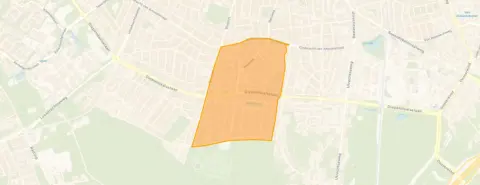 Area
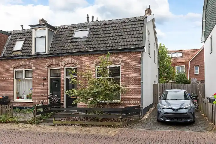
AreaA 1914 end-of-terrace house in Bloemenkwartier Zuid
Tucked into the leafy Bloemenkwartier Zuid, this end-of-terrace house from 1914 sits on a quiet street in Hilversum's Zuid district. The home spans two floors and offers 84 square metres of living space according to the BAG registration, while the agent lists it at 89 square metres. With an asking price of €525,000, the price is keen compared to the neighbourhood average asking price of €756,667. For context, [end-of-terrace houses in Hilversum]( /koopwoningen/hilversum/hoekwoningen/) typically command different price points depending on their size and condition.
Inside the home
The house has three rooms in total, including two bedrooms and one bathroom. The interior volume comes to 367 cubic metres across its two floors. The energy label is F, which is the least efficient label, so expect higher energy costs. Built in 1914, the home carries the character of its era without any claims about its current condition.
Life in Bloemenkwartier Zuid
Residents across the municipality of Hilversum give their living environment an average score of 7.61, based on 31 reviews. One resident notes it is a "safe neighbourhood, occasionally some nuisance from young people," while another appreciates the "good accessibility," mentioning that "within a reasonable distance you have supermarkets or the train station." The neighbourhood itself counts about 4,655 inhabitants, with a mix of ages and household types. [The Bloemenkwartier Zuid neighbourhood]( /buurt/bloemenkwartier-zuid-hilversum/) has a housing stock where 79 percent are single-family homes and 38 percent are owner-occupied.
Amenities and transport
The Albert Heijn supermarket is on your doorstep at just 80 metres away, making daily groceries effortless. The Dr. H. Bavinckschool is just around the corner, with the Paulusschool a couple of streets away. Huisartsenpraktijk De Egelantier and Leeuwen Apotheek are both within a five-minute walk. Bus line 104 stops at Hilversum, G. van Amstelstraat just around the corner, and Hilversum Sportpark train station is a ten-minute walk. [The municipality of Hilversum]( /gemeente/hilversum/) offers further amenities within easy reach.
WOZ and address data
At the address level, public risk data indicates road traffic noise at 55 dB Lden, which is above the noise standard, while railway and aircraft noise remain below their standards. The foundation risk indication is low, based on the home being built before 1970 on sandy soil. For climate, pluvial flooding at heavy rain is indicated as medium, while current flood risk and heat stress are low, though heat stress is expected to rise to medium by 2050. These are area-level indications from public data sources, not an inspection of this specific home.
Source
At the time of writing the home is offered via multiple channels, including VAN VULPEN ROOZENBURG MAKELAARS.
This summary was generated with AI and may contain errors. Always verify the details with the provider.
Features
Details of this home
Transfer
Price
Energy
 Save up to € 400 on your energy billCompare now
Areas and volume
 Insure your home and belongingsGet insured
Layout
Construction
Outdoor space
The WOZ value is set annually by the municipality with 1 January as its reference date, and therefore lags the market by about a year. It is an estimated market value, not a sale price.
Frequently asked questions
About Hilvertsweg 98, Hilversum
How does the asking price compare to other homes in the neighbourhood?
The asking price of €525,000 is 31 percent below the neighbourhood average asking price of €756,667. The average asking price per square metre in the neighbourhood is €6,551, while this home is listed at €5,899 per square metre based on the agent's floor area. Six homes are currently available in the neighbourhood, with prices ranging from €245,000 to €1,250,000.
What is the layout of this end-of-terrace house?
The home has three rooms in total, including two bedrooms and one bathroom, spread across two floors. The total volume is 367 cubic metres. According to the BAG registration the living area is 84 square metres, while the agent lists it at 89 square metres. The plot measures 135 square metres according to both the BAG registration and the agent.
What does the energy label F mean for this home?
Energy label F is the least efficient label on the scale, which means you can expect higher energy costs compared to more efficient homes. The label reflects the home's energy performance as registered, without indicating anything about the structural condition of the building. The home was built in 1914, which is a fact about its age rather than a statement about its current state.
What are the noise levels around this address?
Public risk data at the address level indicates road traffic noise at 55 dB Lden, which is above the noise standard. Railway noise is measured at 27 dB Lden and aircraft noise at 44 dB Lden, both below their respective standards. These figures come from public data sources and represent area-level indications rather than measurements taken at the property itself.
What is the foundation risk for this home?
The foundation risk indication for this address is low. This is based on the home being built before 1970 and the soil type being sand. This is an area-level indication from public data sources, not an inspection of this specific property. The home was built in 1914, which is a fact about its construction year rather than a diagnosis of its foundation condition.
What supermarkets are nearby?
An Albert Heijn supermarket is located just 80 metres from the home, making it very convenient for daily shopping. Further Albert Heijn branches are at 798 and 989 metres, with a SPAR express at 1,176 metres and a Dirk at 1,277 metres. In total, 23 supermarkets are within a 5-kilometre radius.
Which schools are close to this home?
The Dr. H. Bavinckschool is the nearest primary school at 152 metres, followed by the Paulusschool at 470 metres and the Violenschool at 486 metres. The Fabritiusschool is at 640 metres and the Montessorischool Zuid at 667 metres. In total, 61 schools are within a 5-kilometre radius of the home.
How is the public transport connection from this address?
Bus line 104 stops at Hilversum, G. van Amstelstraat at 153 metres, at Hilversum, Egelantierstraat at 162 metres, and at Hilversum, Neuweg at 202 metres. The nearest train station is Hilversum Sportpark at 1,354 metres. The nearest GP is Huisartsenpraktijk De Egelantier at 400 metres and the nearest pharmacy is Leeuwen Apotheek at 392 metres.
What do residents say about living in this area?
Residents across the municipality of Hilversum give their living environment an average score of 7.61, based on 31 reviews. One resident describes it as a "safe neighbourhood, occasionally some nuisance from young people." Another notes "good accessibility," saying that "within a reasonable distance you have supermarkets or the train station." These reviews reflect the wider municipality rather than this specific neighbourhood.
What is the flood risk for this address?
Public climate data indicates that pluvial flooding at heavy rain is at a medium level for this address. The current flood risk is low, and the flood risk for 2050 is also low. Heat stress is currently low but is expected to rise to medium by 2050. These are area-level indications from the Klimaateffectatlas, not an assessment of this specific property.