Hagelingerweg 283
Kerkpadbuurt, Velsen
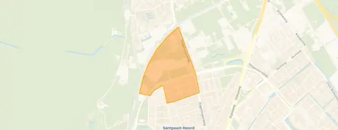 Area
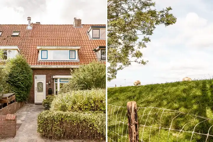
AreaA 1935 terraced house in Santpoort-Noord
This terraced house on Hagelingerweg 283 sits in the Kerkpadbuurt, a quiet corner of Santpoort-Noord where the streets feel settled and green. The home dates from 1935 and carries an energy label D, which means you can expect moderate energy costs. With an asking price of €695,000, the price per square metre comes to €5,650 based on the agent's floor area, which puts it on the high side compared with other [terraced houses in Velsen].
Inside the home
The agent describes a five-room layout spread over three floors, with four bedrooms and one bathroom. The living area is given as 123 m² in the listing, while the BAG registration records 143 m². The plot measures 237 m² according to both sources. The home has a volume of 508 m³.
The Kerkpadbuurt
Life here revolves around the nearby Wijkeroogpark, which a resident describes as being right on your doorstep. Across the municipality of Velsen, residents give their living environment an average score of 7.29, based on fourteen reviews. One resident says: "Safe, clean, lots of nature." Another notes that many older homes in the area suffer from poor insulation and high energy costs. The neighbourhood itself counts around 660 inhabitants, with a mix of ages and a high share of owner-occupied homes. For a closer look at [the Kerkpadbuurt neighbourhood], the data paints a picture of a stable, family-oriented community.
Amenities and transport
Daily errands are well covered. The Dekamarkt is just around the corner, with a Vomar a bit further out. For primary education, Parnassia and Openbare Basisschool De Pionier are both within a ten-minute walk. The GP practice Roos en Beek is a couple of streets away, and Apotheek 't Sant is nearby too. Bus line 3 stops at Santpoortsedreef on your doorstep, while line 481 stops at Cremerlaan oost and Kerkweg. The train station Driehuis is a ten-minute walk, and the Spaarne Gasthuis hospital in Haarlem-Noord is a short drive.
WOZ and address data
The WOZ value is not stated in the available data. As for the address, public risk data gives area-level indications. Road traffic noise is measured at 68 dB Lden, above the noise standard, while railway and aircraft noise stay below their standards. The foundation risk indication is low, on sandy soil. Pluvial flooding at heavy rain is indicated as medium, while the current flood risk and the 2050 flood risk are both low. These are area-level indications, not an inspection of this specific home.
Source
At the time of writing, the home is offered only via VAN WAALWIJK VAN DOORN MAKELAARS.
This summary was generated with AI and may contain errors. Always verify the details with the provider.
Features
Details of this home
Transfer
Price
Energy
 Save up to € 400 on your energy billCompare now
Areas and volume
 Insure your home and belongingsGet insured
Layout
Construction
Outdoor space
Frequently asked questions
About Hagelingerweg 283, Santpoort-Noord
What does the energy label D mean for this home?
The energy label D is a middle-of-the-road label, so you can expect moderate energy costs. It does not tell you anything about the condition of the home itself. The house was built in 1935, which is a fact about its age, not a judgement on its maintenance. If you want to know how the home performs in practice, the agent's listing is the place to look for details.
How does the asking price compare to the market?
The asking price is €695,000 for a terraced house with a living area of 123 m² according to the agent, which works out to €5,650 per square metre. The BAG registration records a larger living area of 143 m². Based on the agent's floor area, the price per square metre is on the high side compared with other terraced houses in Velsen.
What is the layout of this home?
According to the agent, the home has five rooms in total, including four bedrooms and one bathroom, spread over three floors. The volume is 508 m³. The plot measures 237 m². The living area is listed as 123 m² by the agent, while the BAG registration gives 143 m². Both figures are mentioned in the data, without a single 'correct' one.
What is the WOZ value of this property?
The WOZ value is not stated in the available data. The WOZ is the municipal valuation used for taxes, and it is not part of the listing information provided here. Without this figure, it is not possible to compare the asking price to the official valuation.
What are the noise levels around this address?
Public risk data indicates that road traffic noise at this address is 68 dB Lden, which is above the noise standard. Railway noise is 40 dB Lden and aircraft noise is 44 dB Lden, both below their respective standards. These are area-level indications based on public data, not measurements taken at the property itself.
What is the foundation risk for this home?
The foundation risk indication for this address is low, according to public data. The soil type is sand, and the home was built before 1970, in 1935. This is an area-level indication, not an inspection of the specific property. It gives a general sense of the risk, but it does not replace a structural survey.
What about flooding risks at this location?
The climate risk data for this address shows a medium indication for pluvial flooding, which means flooding from heavy rain. The current flood risk is low, and the flood risk for 2050 is also low. These are area-level indications from the Klimaateffectatlas, not a guarantee for this specific home.
Which supermarkets are closest to this home?
The nearest supermarket is a Dekamarkt at about 590 metres, which is a five-minute walk. A Vomar is at about 1.2 km, and another Dekamarkt at about 1.3 km. An Albert Heijn and a PLUS are further out, at around 2.5 km. For daily groceries, the Dekamarkt is the most convenient option.
What schools are nearby?
Several schools are within walking distance. Parnassia, a primary school, is at about 1.1 km, and Openbare Basisschool De Pionier is at about 1.2 km. There is also a school for voortgezet speciaal onderwijs, Het Molenduin Santpoort, at about 1.1 km. Secondary education is available at about 1.4 km.
How is the public transport connection?
The bus stop Santpoortsedreef is on your doorstep, served by bus line 3. Two other stops, Cremerlaan oost and Kerkweg, are within a short walk and are served by bus line 481. The nearest train station is Driehuis, at about 466 metres, which is a five-minute walk.
What is the neighbourhood like?
The Kerkpadbuurt is a small neighbourhood with around 660 residents. A resident of the municipality describes the area as safe and clean, with lots of nature, and mentions the Wijkeroogpark as a highlight. Another resident notes that some older homes in the area have insulation issues. The neighbourhood has a high share of owner-occupied homes, at 91%.